September 3, 2020
The Atlantic Coastal Fish Habitat Partnership (ACFHP or Partnership) is pleased to announce the launch of its newest science product: the Fish Habitat Conservation Area Mapping and Prioritization Project. ACFHP worked with The Nature Conservancy and Southeast Aquatic Resources Partnership create static maps of conservation opportunity areas for diadromous, estuarine, and coastal habitat from Maine through Florida. The southeast maps were funded by NOAA Southeast Regional Office, and the northeast maps were funded by NOAA Greater Atlantic Regional Fisheries Office.
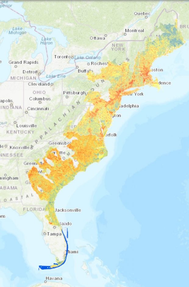
The map results will help ACFHP, its partners, and various stakeholders better identify locations in need of habitat conservation – both “Areas of Excellent Fish Habitat” that could benefit from land and watershed protection and expansion, and “Restoration Opportunity Areas” that would most benefit from on the ground restoration. It is not intended to be used as guidance for regulatory purposes. ACFHP plans to include the results of this project in the evaluation criteria for FY2021 National Fish Habitat Action Plan/US Fish and Wildlife Service funding; the RFP will be announced later this week.
There are a total of eight maps, or analyses, addressing all of ACFHP’s priority habitats within each of its four subregions (North, Mid-, South Atlantic; and South Florida). The diadromous analyses were conducted in the North, Mid-, and South Atlantic and address ACFHP’s riverine priority habitat in those subregions. The estuarine analyses cover the entire coast, addressing ACFHP’s shellfish beds, submerged aquatic vegetation, and tidal vegetation priority habitats. The coastal analysis in South Florida covered that subregion’s coral and live/hard bottom priority habitat.
For both the diadromous and estuarine analyses, 7-8 metrics which describe some aspect of the suitability or condition of the habitat were calculated. Impervious surface, point and non-point source pollution, potential for species access, riparian buffer extent, and more were included in the diadromous analyses. Habitat coverage, proximity to development and protected habitat, water quality, and hardened shorelines were some of the variables included in the estuarine analyses. The South Florida Coastal Analysis was not scored like the diadromous and estuarine analyses; instead, coral extent and Habitat Area of Particular Concern designations were mapped.
For links to the maps, final report, user guide, and a video on how to view the maps on Databasin, visit the science and data section of the ACFHP website: https://www.atlanticfishhabitat.org/science-and-data-projects/. For more information, or to recommend data for future updates, please contact Lisa Havel, ACFHP Coordinator, at lhavel@asmfc.org.